| Aircraft | Weight | 1665 g (ABX41-D smart battery, Fusion 4T V2 gimbal, and propellers included)
|
| Max. Takeoff Weight |
1999 g |
| Dimensions | 563×657×147 mm (unfolded, incl. propellers) |
| Diagonal Wheelbase | Diagonal: 467 mm
|
| Max Ascent Speed | Slow: 2.5 m/s
Smooth: 3 m/s
Standard: 6 m/s
Ludicrous: 8 m/s |
| Max Descent Speed | Slow: 2.5 m/s
Smooth: 3 m/s
Standard: 6 m/s
Ludicrous: 6 m/s |
| Max Horizontal Speed (windless near sea level) | 23m/s |
| Maximum Takeoff Altitude | 13,124 ft (4000m) |
| Max Flight Time (windless) | 42 minutes
* Test data from lab with windless environment in the speed of 8 m/s during horizonal flight and only for reference. |
| Max Hover Time (windless) | 37 minutes
* Test data from lab with windless environment during hovering and only for reference. |
| Max Wind Resistance |
12 m/s |
| IP Rating | IP43 |
| Max Tilt Angle | Slow: 10°
Smooth: 30°
Standard: 30°
Ludicrous: 36° |
| Max Angular Velocity | Pitch axis: 300°/s
Yaw axis: 120°/s |
| Operating Temperature | -20℃~+50℃ |
| Operating Frequency | 2.4G/5.2G*/5.8G/900MHz*
*5.2GHz is only applicable for FCC, CE, and UKCA regions. 900MHz is only applicable for FCC regions. |
| GNSS | GPS+Galileo+BeiDou+GLONASS |
| Transmitter Power (EIRP) | 2.4GHz: <33dBm(FCC), <20dBm(CE/SRRC/MIC)
5.8GHz: <33dBm(FCC), <30dBm(SRRC), <14dBm(CE)
5.15-5.25GHz: < 23dBm(FCC/SRRC/MIC)
5.25-5.35GHz: <30dBm(FCC), <23dBm(SRRC/MIC) |
| Hovering Accuracy | Vertically
±0.1 m (when visual positioning works normally)
±0.5 m (when GNSS works normally)
Horizontally
±0.3 m (when visual positioning works normally)
±0.5 m (when high-precision positioning system works normally) |
| Gimbal | Mechanical Range |
Tile: -135° to 45°
Roll: -50° to 50°
Pan: -45° to 45° |
| Controllable Range |
Tilt: -90° to 30° |
| Stable system | 3-axis mechanical gimbal (tilt, roll, pan) |
| Max. Control Speed (pitch) | Tilt: 100°/s
|
| Angular Vibration Range | < 0.005°
|
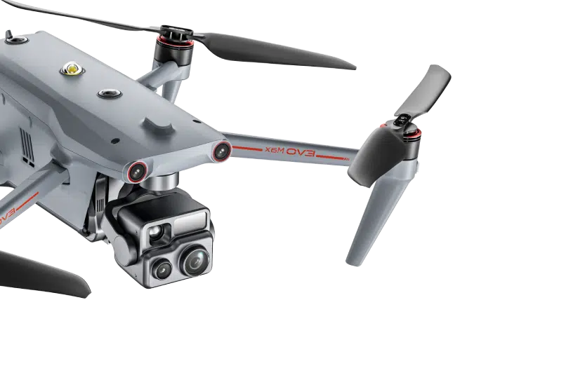
Zoom Camera
(Telephoto) | Sensor | 1/2″ CMOS. Effective pixels: 48M |
| Lens | DFOV: 40°-10.3°
Equivalent Focal Length: 64 – 234 mm
Aperture: f/2.8 – f/4.8
Focus: 2 m ~ ∞ |
| Exposure Compensation | ±3EV 0.3EV/step |
| ISO Range | Auto: ISO100 ~ ISO6400
Manual: ISO100 ~ ISO6400 |
| Electronic Shutter Speed | Photo: 8s ~ 1/8000
Video: 1s ~ 1/8000 |
| Max Photo Size | JPG: 4000×3000, 8000×6000
DNG: 4000×3000 |
| Max. Video Resolution | 4000×3000@30fps
|
| Wide Camera | Sensor | 1/2″ CMOS. Effective pixels: 48M
|
| Lens | DFOV: 83.4°
Equivalent focal length: 24 mm
Aperture: f/2.8
Focus: 1.5 m ~ ∞ |
| Exposure Compensation | ±3EV 0.3EV/step |
| ISO Range | Auto/Manual: ISO100 ~ ISO6400
Night Mode: ISO100 ~ ISO320000 (auto) |
| Electronic Shutter Speed | Shooting: 8s ~ 1/10000s
Recording: 1/30s ~ 1/10000s |
| Max. Video Resolution | 4000×3000@30fps
Night Mode: 2400×1800@30fps |
| Photo Size | JPG: 4000×3000, 8000×6000
DNG: 4000×3000 |
| Thermal Camera | Thermal Imager | Uncooled VOx Microbolometer |
| Lens | FOV: 61°
Focal length: 9.1 mm
Aperture: f/1.0
Focusing distance: 2.2 m ~ ∞ |
| Infrared Temperature Measurement
Accuracy | ±2℃ or reading ±2% (using the larger value) @ ambient temperature ranges from -10℃ to 50℃
|
| Video Resolution | 640×512@30fps
|
| Photo Size | 640×512
|
| Pixel Pitch | 12 um |
| Temperature Measurement Method | Center Point Temperature Measurement/Spot Temperature Measurement/Area Temperature Measurement
|
| Temperature Measurement Range | High Gain Mode: -20℃ to 150℃
Low Gain Mode: 0 to 550℃ |
| Temperature Alert | In area temperature measurement, high and low temperature alarm thresholds, reporting coordinates and temperature values are supported
|
| Palette | White Hot/Black Hot/Ironbow/Rainbow 1/Rainbow 2/Lava/Arctic/Ironbow/Medical/Tint
|
| Laser Rangefinder | Measurement Accuracy | 905 nm
|
| Measuring Range | 5 – 1200 m
|
| Image Transmission | Operating Frequency | 2.4G/5.2G*/5.8G/900MHz*
*5.2GHz is only applicable for FCC, CE, and UKCA regions. 900MHz is only applicable for FCC regions. |
| Max Transmission Distance
(unobstructed, free of interference) | 20km(FCC), 8km(CE) |
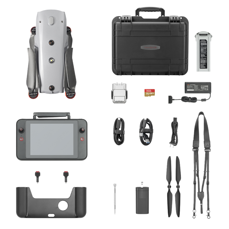
| Independent Networking | 7.9-inch Smart Controller |
| Transmitter Power (EIRP) | 2.4GHz: <33dBm(FCC), <20dBm(CE/SRRC/MIC)
5.8GHz: <33dBm(FCC), <30dBm(SRRC), <14dBm(CE)
5.15-5.25GHz: < 23dBm(FCC/SRRC/MIC)
5.25-5.35GHz: <30dBm(FCC), <23dBm(SRRC/MIC) |
| Autonomy | Non-GPS Hovering and Manual Flight | Indoor: Horizontal error ≤3cm (At least have texture at one direction)
Outdoor:
Daytime: Within 500m flight height, horizontal error < 0.01*height
Night: Manual flight is controllable within 100m flight height |
| Non-GPS Return-to-Home | Within 500m flight height, horizontal error of Return-to-Home point < 30cm |
| Automatic Obstacle Rerouting | High Speed Obstacle Rerouting: Flight speed up to 45mph(20m/s) when Min. safety distance to obstacle is 4.9ft (1.5m)
High Precision Obstacle Rerouting: Flight speed could reach 6.7mph(3m/s) when Min. safety distance to obstacle is 1.6ft (0.5m) |
| Multi-target Recognition and Tracking | Target identification types: people, vehicles, boats
Number of targets detected: 64
Comprehensive recognition accuracy: > 85% |
| Millimeter-wave Radar Sensing System | Frequency | 24G: 24.0 – 24.25 GHz
60G: 60 – 64 GHz |
| Size | 1.5*0.55*0.08 in(L*W*H) |
| Weight | 0.07oz (2g) |
| EIRP | 18dBm |
| Sensing Range | 60G millimeter-wave radar:
Upward: 0.3 ~ 18 m @ high voltage transmission line
Downward: 0.15 ~ 40 m @ concrete floor
Forward & Backward: 0.15 ~ 18 m @ high voltage transmission line, with flight speed 10 m/s
Sidewards: 0.15 ~ 18 m @ high voltage transmission line, with flight speed 10 m/s
24G millimeter-wave radar:
Downward: 0.8 ~ 12 m @ concrete floor |
| FOV | Horizontal (6dB): ±30°/±15° (60G/24G)
Vertical (6dB): ±40°/±15° (60GHz/24G) |
| Speed Measurement Range | ± 134mph (60m/s) |
| Speed Measurement Accuracy | ≤1% |
| Max. Target Detection Number | 32 |
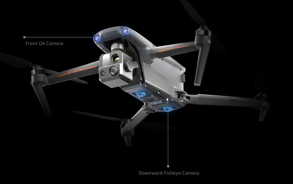
| Visual Sensing System | Obstacle Sensing Range |
Forward: 0.5 ~ 30 m
Backward: 0.5 ~ 25 m
Sidewards: 0.5 ~ 40 m
Upward: 0.5 ~ 40 m
Downward: 0.5 – 35 m |
| FOV | Forward & Backward: 60°(H), 80°(V)
Upward: 180° (sidewards), 120° (forward & backward)
Downward: 180° (sidewards), 120° (forward & backward) |
| General Specifications | Screen | 7.9 inch, 2000nits max. brightness, 2048*1536 resolution |
| External Battery | Capacity: 5800mAh
Voltage: 11.55V
Battery Type: Li-on
Energy: 67Wh
Charing time: 120mins
Intelligent Lithium Ion Battery |
| Operating Time | 3 hours (Max. brightness)
4.5 hours (50% brightness) |
| Max Transmission Distance
(with interference) | FCC: 20km
CE: 8km |
| IP Rating | IP43 |
| Storage | 128G |
| GNSS | GPS+GLONASS+Galileo+Beidou+NavIC+QZSS |
| Operating Temperature | -20℃ to 40℃ |
| WIFI | Protocol | 802.11a/b/g/n/ac/ax
|
| Operating Frequency[ |
2.4G: 2.400–2.476GHz*,2.400–2.4835GHz
5.2G: 5.15-5.25GHz**,5.17-5.25GHz***
5.8G: 5.725-5.829GHz*,5.725-5.850GHz
* Only applies to SRRC regions
** Only applies to FCC, CE (Germany excluded) and UKCA regions
*** Only applies to Germany
Note: Some frequencies are only available in some regions or for indoor use only. For details, please refer to local laws and regulations. |
| Transmitter Power (EIRP) | 2.4G:
≤30dBm (FCC/ISED); ≤20dBm (CE/SRRC/UKCA)
5.2G:
≤30dBm (FCC); ≤23dBm (CE/UKCA)
5.8G:
≤30dBm (FCC/ISED/SRRC); ≤14dBm (CE/UKCA) |
| Aircraft Battery | | |
| General Specifications | Capacity | 8070mAh |
| Voltage | 14.88V |
| Battery Type | LiPo 4S |
| Energy | 120wh |
| Net Weight | 520g |
| Charging Temperature | 5ºC to 45ºC(When the temperature is lower than 10° C (50° F), the selfheating function will be automatically enabled. Charging in
a low temperature may shorten the lifetime of the battery) |
| Hot Swap | Support |
| | Smart Battery Station(planning) |
| General Specifications | Dimensions | |
| Net Weight | |
| Compatible Battery Type | |
| Input | |
| Output | |
| Output Power | |
| USB-C Port | |
| USB-A Port | |
| Power Consumption
(when not charging battery | |
| Output Power
(when warming up battery | |
| Operating Temperature | |
| IP Rating | |
| Charging Time | |
| Protection Features | |


